Tuesday, August 21, 2012
Thursday, August 9, 2012
Final Submission - Stage Design Model and Poster
 |
| Final poster |
Tuesday, August 7, 2012
Final Submission - Concertina Book
 |
| Cover page - a much bigger scale of Parramatta region. and North point down to right, identify the orientation for the below drawings |
 |
| Buildings are all spread along the river and main street, George St, Church St, Macquarie St. |
 |
| Street grid expanded |
 |
| Street grid expanded further gain, especially vertically to the southern side of river and northern. |
 |
| current Parramatta city pattern formed |
 |
| narrow land added to the pattern |
 |
| To me, building emphasized the fact that trees are squeezed out from the southern side of the river . |
 |
| Reversed map lets open space stands out. |
 |
| 3 blocks located along the Church St showing the continuously change of street pattern |
 |
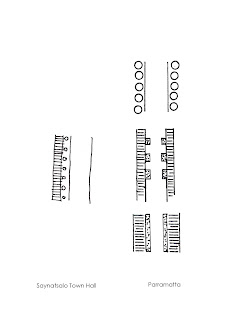
| Street pattern in plan. horizontal lines are pedestrian pathway, dots indicate hedges along the street, circles are the umbrella (or tank) in the third block. |

 |
| solar analysis. Any objects projecting out from the ground are hatched in solid dark, while the blank space are the ones do not have influence on site or being affected by the proposing theatre. |
Week 3 Submission - Project 1 - Interimb
 |
| 1792 Building Allocation & George St and Church St named |
 |
| 1804 More Streets are named and free settlers came |
 |
| 1823 Much more free settlers came, street grid system improved |
 |
| 1792 Building lots allocated to released convicts , along the main streets. |
 |
| 1804 habitable zone are further allocated to released convicts and free settlers |
 |
| 1823 wider range of street system as well as allotment. |
 |
| Nowadays Parramatta urban pattern |
 |
| Reversed map showing the space left-over from built environment |
 |
| St'John's Cathedral. pointed at the existing historical architecture map |
 |
| The traditional building facade interestingly merged with the modern building on Church St. |
 |
| Rear Park on the western side of Riverside Theatre site |
 |
| Large scale map - Parramatta |
Subscribe to:
Comments (Atom)


